Can sprawl be good for you?
Our city’s streets might be confusing, but they might also make you happy
When University of Winnipeg geography professor John Lehr first moved to Winnipeg from Edmonton in 1973, he found the city’s street pattern confusing.
“I was lost at first,” Lehr said. “It took me awhile to get orientated.”
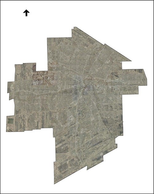
Lehr said that from an aerial view, Winnipeg looks like it has a normal street grid pattern, but it does not.
A normal street grid pattern would see streets running north to south or east to west.
Instead, Winnipeg is arranged based on an initial survey system, conducted in 1813. Lehr said Winnipeg’s street patterns come from Miles MacDonell, governor of the Red River Settlement from 1812 to 1815, who surveyed the rivers and divided city lots along the rivers into narrow strips.
As a result, Winnipeg’s streets curve around the Red and Assiniboine Rivers.
“It makes Winnipeg a little more interesting than Edmonton or Regina,” Lehr said.
City of Winnipeg planners constantly use aerial photographs of the city to see the spatial relationship between roads, neighbourhoods, buildings and pathways, said John Wintrup, principal planner in the city’s Planning and Land Use Division.
“The perception of space is not the same when you look at an aerial photo compared to ground level,” Wintrup said.
Christopher Leo, politics professor at the U of W, said an aerial look onto Winnipeg reveals all the empty spaces in the city.
“The city tends to build on the other side of empty spaces,” he said, calling that practice leapfrogging. He cited Transcona West as one example of this pattern.
Leapfrogging can lead to city sprawl.
“There’s perfectly usable empty spaces beside it,” Leo said, noting it costs the city more to extend services to cover that extra mileage – not to mention the environmental impact of sprawl.
U of W geography professor Salah Hathout believes sprawl is not good city planning, as it involves using up more agricultural land.
“It leaves less resources for the next generation,” Hathout said.
Winnipeg’s population density is very low compared to the space it occupies, at 1,400 people per square kilometre.
“It’s not economically viable for the long term,” Lehr said. “It’s difficult to have an effective transit system.”
But city sprawl could also have positive benefits for Winnipeg. Sprawl helps separate communities develop a strong sense of neighbourhood identity, Lehr said.
As city planner, Wintrup’s must also consider the psychological elements of space.
He said it is the same as decorating your home, and cites the curving streets and cul-de-sacs of suburbs as an example.
“It’s creating a park-like setting that is easy to drive through,” Wintrup said. “The grid pattern is chaotic.”
Trees also add a psychological mood to the city and are easily seen from an aerial view, Hathout said.
He said that lower income areas tend to have poorer landscapes, because their maintenance is prioritized after the upkeep of higher income areas.
This contributes to a lower mood in poorer neighbourhoods.
“The mood of the people reflects on their productivity, their recreation, as well as their potential for having conflict,” Hathout said.
Winnipeg also lacks freeways, something that Wintrup said was a choice of the city’s forefathers.
“Freeways can rip the soul out of a city,” Lehr said.